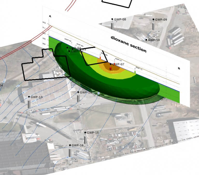
Groundwater plume and flow direction visualization for a client with limited budget.
Environmental 3D Visualization “State of the Union”
Environmental 3D Visualization “State of the Union”
Though this past year has been very challenging for many, both professionally and personally, there have been some exciting developments in environmental three-dimensional visualization and analysis (3DVA), both within our company and in the industry at large. In this article, I will attempt to bring everyone up to speed with developments in three different areas of 3DVA that impact the work we do at Environmental Standards.
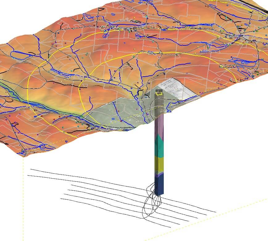
Topography, borehole, and geologic unit visualization for an energy client in the Northeast.
State of the Practice
This past year we have seen the demand for our 3DVA services increase substantially. The company has used 3DVA to support many exciting projects out of the Charlottesville, Virginia office. The following list includes just some of the project tasks Environmental Standards personnel have been performing to support and grow the 3DVA practice:
- A 3D visualization model (3DVM) was used as the nexus for historical and new information synthesis and for graphics generation to support a significant conceptual site model update for a landfill Superfund site in Pennsylvania.
- Complex 3D visualizations of natural gas field wells and geology in Pennsylvania were developed for confidential clients to support forensic field investigations. Animations of changing subsurface condition contours over multiple time periods were created.
- Quick-turnaround 3DVMs were developed for several small sites with chlorinated volatile organic compound (CVOC) impacts that would traditionally not have the budget to support 3D visualizations. But with today’s much lower levels of effort and lower costs to create 3DVMs, these smaller clients are now able to benefit from the differentiating capabilities offered by 3DVA tools.
- We supported a strategic client with 3DVMs for multiple generation sites used in a quality assurance/quality control (QA/QC) capacity to identify data gaps, visually present the results of database analyses, and communicate complex site processes with multiple stakeholders and contractors.
- We began training and mentoring additional staff to support 3DVA projects by processing data, creating input files, and increasing proficiency in core 3DVA skills like Geographic Information System (GIS) and database management, thus increasing our 3DVA bench strength.
- An Environmental Standards 3DVA-focused project abstract was accepted for a poster presentation at the 2021 Battelle Chlorinated Conference (the conference was recently cancelled due to COVID, but we hope to present there in 2022!).
State of the Business
Seequent, the software company that develops the flagship 3D visualization software (Leapfrog) we use at Environmental Standards, is being acquired by Bentley Geosystems, one of the world’s leading infrastructure engineering software companies.
This acquisition is evidence of the arrival of a synthesized aboveground (e.g., BIM, 3D CAD) and belowground (Leapfrog) visualization paradigm that has long been promised within the industry. This deal is also a big recognition of and investment in Leapfrog and Seequent, which indicates that this tool won’t be going anywhere for a long time, that new exciting and differentiating features will continue to be added, and that the investment Environmental Standards has made in this tool in particular and in environmental 3D data visualization in general has been a sound one.
State of the Science
A new suite of features for working with chemical concentrations inside of Leapfrog was introduced last year by Seequent. The features are provided in an extension to the main software license called the Contaminants Extension.
With the introduction of the Contaminants Extension, Leapfrog has stepped its “chemical interpolation and visualization game” up to the level of and even surpassing the specialty leader in this area, C-Tech’s Earth Volumetric Studio (EVS) software. Previously, it is the author’s opinion that, Leapfrog beat out EVS in almost every area (e.g., geological visualization, ease-of-use, intuitive design, speed of model creation), except for working with chemicals in the environment in 3D. Now that these new chemical capabilities have been added to Leapfrog, it truly is a one-stop-shop for advanced environmental visualization.
The Contaminants Extension will allow the Environmental Standards staff to perform advanced 3D analyses such as:
- Create 3D plume visualizations;
- Use block models to quickly calculate mass and volume of plumes and impacted soil zones at different concentration thresholds to support excavations, in-situ treatment, and other field efforts;
- Integrate plume models with geological models using intuitive and robust geostatistics modeling tools; and
- Ensure defensible estimates by validating the results in a 3D interactive environment to create the best interpretations, including quantifying 3D model uncertainty and goodness of fit (e.g., generating variograms and performing statistical analyses).
The Level of sophistication brought to our projects through 3DVA services is ever-expanding, and if you have interest in better understanding how this technology can be used to visually model your site, feel free to call Jonah Jackson at 434.293.4039. Jonah can also be contacted at jjackson@envstd.com.