Have you ever thought about visualizing your site data in three dimensions (3D)? Are you unsure about the value and worried about eating up lots of time and project budget?
Worry no more. A new batch of sophisticated 3D Visualization and Analysis (3DVA) tools have dramatically altered the equation in favor of implementing high-value 3DVA across all stages of the project life-cycle to accelerate geoscience projects. These new programs can create models in less time and with more features, including vastly enhanced live model outputs to clients. The learning curve is also much less steep – the tools are much more user friendly. As 3DVA tools have evolved, their potential applications have increased. They are no longer just pretty, expensive pictures. They are powerful tools for communicating, identifying data gaps, reducing risk, and for institutional knowledge transfer and storage.
Environmental Standards, Inc. (Environmental Standards) offers insightful and differentiating 3DVA services to support its geoscience, information management, and chemistry practices to enhance project delivery in a multitude of ways. Our expert-level staff are some of the most proficient in the industry.
Some specific benefits of 3DVA include:
- Analyze site history quickly and completely
- Streamline development of subsurface conceptual models
- Support consensus-building and collaborative problem solving
- Identify data gaps
- Reduce decision risk
- Optimize sampling locations and excavation areas
- Drive project planning and development of remedial strategies
- Reduce long-term project costs
- Visualize and quantify impacts of treatment systems/remedial actions
- Create powerful, effective presentations and narrated animations of site processes
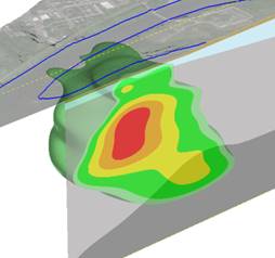
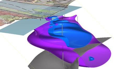
3DVA not only helps with data evaluation, but also helps bridge the gaps among consultants, clients, regulators, and the public by presenting easy-to-understand visualizations of complex site processes and treatment/cleanup plans. Vivid 3D graphics and animations convey critical information in easy-to-understand terms. The human brain thinks and understands in 3D. Seeing your site data combined with historical data and graphics for the first time in 3D can be revelatory. A well-developed 3D model allows Project Teams to build confidence that the conceptual site model is well understood and everyone is on the same page. This confidence generates cost savings and efficiencies throughout the project life-cycle:
- Proposal - Show site understanding quickly from synthesizing historical data in 3D
- Project Planning - Use existing 3D data to focus subsequent work
- Remedial (Site) Investigation (RI) - Create 3D conceptual site model, calculate impacted volumes
- Feasibility Study (FS) - Evaluate remedial alternatives by first visualizing in 3D
- Remedial Design (RD) - Refine and display chosen remedial approach in 3D
- Remedial Action (RA) - Optimize remedial approach in near real-time by visualizing changing datasets
- Operations and Maintenance (O&M) - Evaluate O&M results and present in 3D
Environmental Standards’ staff has provided 3DVA services for a wide range of applications:
- Environmental Site Assessment and Risk Assessment
- Remedial Design and Implementation
- Contaminant Transport and Groundwater Model Visualization
- Air Quality Modeling
- High-Resolution Site Characterization
- Mass Flux/Mass Discharge
- Brownfields/Redevelopment
- Permitting and Compliance
- Stormwater Management
- Pipeline Installation and Monitoring
- Geothermal Visualization
- Infrastructure/Civil Works Projects
At Environmental Standards, we see an industry moving towards 3DVA eventually becoming standard practice on most geoscience projects, and not just as a special add-on service. Just like geographic information system/computer-aided drafting (GIS/CAD) maps are now used to store spatial data on virtually every project, there is no reason these same data should not be stored from the outset in a 3D format – to reflect their origination in our 3D world. Our conceptualization of 3DVA is that it is a tool just like GIS or a Microsoft® Excel® spreadsheet that is used to analyze data more efficiently and add value for clients. It just happens to be an extremely powerful tool that can provide incredible new insights and perspectives on your geoscience projects. We believe that this paradigm shift in the approach to 3DVA is a powerful differentiator for Environmental Standards and positions us as leaders and innovators within the industry.
Jonah Jackson has over 18 years of experience on groundwater and remediation projects leveraging state-of-the-art visualization and data management tools to solve complex environmental problems, with a focus on the visual articulation of complex data sets to activate key decisions. To discuss how 3DVA can benefit your projects, you can reach Jonah at jjackson@www.envstd.com.